
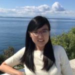
Tutorials 2022
These Tutorials given by the best specialists in the field are prepared for the XXIV ISPRS Congress participants to bring their knowledge at the state of the art or to be introduced to new scientific and technological advances and developments.
Tutorials are open to all XXIV ISPRS Congress participants. The number of places per tutorial is limited so please register as soon as possible.
You can find the rates for half- and full day Tutorials HERE. Registrations for Tutorials will open in conftool soon.
List of tutorials
Day 1
05 Jun 2022
#15 CANCELLED – CARS, a satellite multi view stereo pipeline (half day – morning)
CARS, a satellite multi view stereo pipeline (full day) This tutorial presents how to use the Python API of CARS / PANDORA, based on xarray, to realize all the... Read More

David Youssefi

Emmanuelle Sarrazin
#1 3D Deep Learning For Remote Sensing (full day)
Abstract: This tutorial presents an overview of the recent developments in neural network architecture for the semantic segmentation of 3D point clouds. We will present the different competing paradigms making... Read More
Damien ROBERT
Romain LOISEAU

Loic Landrieu
09:00
#3 Multi-stereo Satellite Images data processing for Digital Surface Modeling (half day – morning)
High-resolution (High-res) satellite images nowadays can observe ground as small as a 30-cm footprint (e.g. worldview 3/4 sensors) and play an important role in wide-area 3D data generation. Such images... Read More

Rongjun Qin
#7 Deep Learning for Time-Series Classification (half day – morning)
Dynamics on the Earth’s surface are governed by continuous temporal processes that can be observed in discrete intervals by Earth observation satellites. Recent satellite constellations, such as Landsat-8 and Sentinel-2, ... Read More
Zhou Zhang

Marc Rußwurm

Charlotte Pelletier
09:00
#9 CANCELLED – Using the right kind of PS-InSAR – Different Tools for surface motion estimation with SAR (half day – morning)
Half-Day Tutorial for students, researchers, and practitioners working or interested in the field of PS-InSAR and related techniques. It is intended for beginners, but also experienced users struggling with the... Read More

Timo Balz
#11 CANCELLED – Calibration Techniques and Accuracy Considerations for Single and Multi‐Camera Systems (half day – morning)
Calibration of any camera system is essential to ensure that image measurements result in accurate estimates of locations and dimensions within the object space. The emphasis of this tutorial is ... Read More

Thomas Luhmann
Stuart Robson

Mark R. Shortis
#13 Dynamic Networks: a hands-on course (half day – morning)
Dynamics Networks (DNs) is a powerful technique for solving arbitrary sensor fusion problems, such as those arising in navigation and mapping applications. For instance, in photogrammetry, all the available sensor... Read More

Ismael Colomina

Jan Skaloud

Davide A. Cucci
#14 CANCELLED – State and Trends in Airborne LiDAR (full day)
Due to the tremendous progress in Airborne LiDAR (Light Detection And Ranging), new sensors and technologies have emerged in recent years. Beyond the constant increase of scan rates and progress... Read More

Gottfried Mandlburger
#4 CANCELLED OTB guided tour (half day – afternoon)
Orfeo ToolBox (OTB) is an open-source library of remote sensing algorithms. Its applications can process all kind of satellite images, from pre-processing steps (calibration, orthorectification, resampling, etc.) to more... Read More
Yannick Tanguy
Emmanuelle Sarrazin
#6 Multi-epoch historical image processing in MicMac (half day – afternoon)
Historical images are a valuable source of information in analyzing the evolution of landscapes. To be able to fully exploit their potential, the images should be precisely calibrated. However, due... Read More

Lulin Zhang

Ewelina Rupnik
#8 Underwater photogrammetry: methods and challenges for mapping and monitoring (half day – afternoon)
This tutorial aims at providing the audience with an introduction to the crucial aspects of underwater photogrammetry, as a key technique for studying and understanding the underwater world in many... Read More
Dimitrios Skarlatos

Fabio Menna

Erica Nocerino
14:00
#10 CANCELLED – The ARTMO toolbox for analyzing and processing of hyperspectral data (half day, afternoon)
This tutorial will focus on the use of ARTMO’s (Automated Radiative Transfer Models Operator) radiative transfer models (RTMs), retrieval toolboxes and post-processing tools (https://artmotoolbox.com/) for the generation and interpretation of... Read More

Jochem Verrelst
14:00
#12 CANCELLED – Earth Datacubes: Concepts, Standards, Services (half day – afternoon)
Datacubes are an accepted cornerstone for offering massive spatio-temporal Earth data in a more user-friendly, easier-to-analyse way. Basis for this is a paradigm shift from files with cumbersome encodings and... Read More

Peter Baumann